-
For more information on how to avoid pop-up ads and still support SkiTalk click HERE.
You are using an out of date browser. It may not display this or other websites correctly.
You should upgrade or use an alternative browser.
You should upgrade or use an alternative browser.
California/Nevada 2023-2024 Tahoe Ski Resorts/Conditions/Meetups
- Thread starter MarkG
- Start date

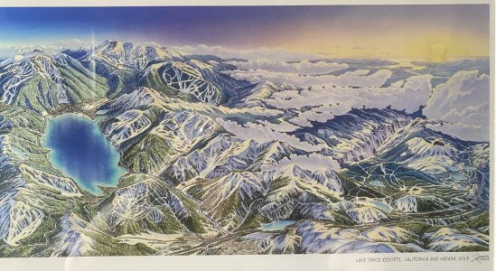
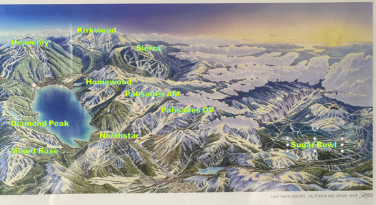
Beautiful. I've never seen that painting before, and I even bought the Niehues book.
I love the North looking South perspective.
Plus... The Gathering is coming to Tahoe in 2024!!!

 www.skitalk.com

OFFICIAL 2024 National Gathering in Tahoe - March 2 - March 9, 2024
2024 National Gathering in Tahoe, March 2 - March 9, 2024 NOTE : This is a living post and will be changed as new information becomes available (last updated 2/19/2024) 3/2/24 UPDATE: DUE TO DRIVING CONDITIONS THERE WILL BE NO OFFICIAL MEETUP TOMORROW. Several of us in Reno are likely to be...
 www.skitalk.com
Only way that all those North facing runs can be seenI love the North looking South perspective.
I have this print on our bedroom wall & the Niehues book too.
That perspective makes Kirkwood look like the place to ski! Sadly, I don’t think Sierra looks like that anymore. Of course I guess it could look better  .
.
 .
.- Joined
- Nov 12, 2015
- Posts
- 6,342
The Niehaus perspective is so off it's hard to fathom. Sierra looks as big as Heavenly (and Homewood a pretty big player) and I can't even think what is what when it comes to Sugar Bowl, Boreal, Soda Springs.
Does make me wonder about the fidelity of his more traditional maps. I know they are only ever "representations" made for useability rather than accuracy but could they play a role in steering crowds to particulalry bits of a mountain based on a fiction?
Does make me wonder about the fidelity of his more traditional maps. I know they are only ever "representations" made for useability rather than accuracy but could they play a role in steering crowds to particulalry bits of a mountain based on a fiction?
The paintings are always twisted though so you can see it represented in 2d. Especially the bigger resorts like Heavenly that have to display 360degrees of aspects.
I wouldn't agree that maps steers people to areas, I feel people use the map to just get where they want to go, not the other way around.
I think clever names for the runs or the liftpod areas have much more influence to steer people to an area than the painting. You call a place 7thheaven or cloud9 you're gonna get a bunch of intermediates. Terminator or meatgrinder gonna get some bros.
The map works because the primary and mental usage of the map is to help new guests make the path they need to take to get from 1 location to another. So clearer pathing with the intersections and forks separated is the primary goal and less about the exact geometry or the topography of the run.
Last edited:
Yup, inaccuracies are why he was commissioned to do over 350 maps world wide.Does make me wonder about the fidelity of his more traditional maps. I know they are only ever "representations" made for useability rather than accuracy but could they play a role in steering crowds to particulalry bits of a mountain based on a fiction?
About James Niehues
Over his 30 year career, James Niehues has painted nearly 200 ski resort maps. Chances are, if you've skied in North America, you have used one of his maps! Check out the full list here!
For some resorts, I don't think I could draw a geographically accurate map from my mind, even ones I've been to 100days. So it is already a warped mental map in my brain which turns to take to get from east peak to stagecoach at heavenly for example, with the fast parts shorter, the slow parts longer.
P.S. Would like to un-ironically thank @fatbob for this interesting debate topic while we wait out shoulder season. This actually made me think what influences guests to go to 1 area or another and my own mental maps.
P.S. Would like to un-ironically thank @fatbob for this interesting debate topic while we wait out shoulder season. This actually made me think what influences guests to go to 1 area or another and my own mental maps.
Last edited:
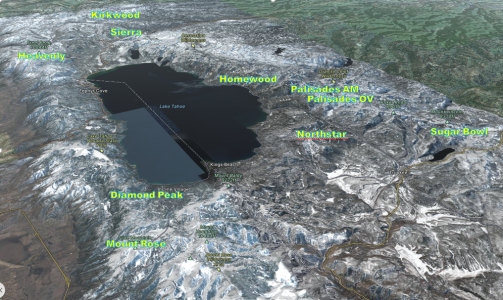
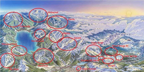
I'm trying to decipher everything on there... does this seem correct? Am I missing anything? Boreal or others?WOOOOHOOOOO...just got an email from @dbostedo suggesting that it's time to start next year. Who am I to argue (though if I've stolen your thread two years in a row my apologies.)
Let it Snow Let it Snow Let it Snow View attachment 209702
- Joined
- Nov 12, 2015
- Posts
- 6,342
Yeah I'm not arguing about Niehaus's skill in doing individual resort representations. I mean his representation is probably how I mentally think of WB for instance because it marries enough physical geographic detail with what you can experience on the ground.
Just I've never (consciously) seen a representation of a wider region and it brings it home how distorted it is to fit the brief being nothing like a pilot or any mapmaker would recognise i.e. it's more of an artwork than anything else.
@dbostedo I think Royal Gorge is probably immedicately abover your Sugar Bowl label and Boreal possibly below and left. Soda Springs to the right of Royal Gorge?
Last edited:
Neihaus maps work much better for most skiers than a skier's map based on an accurate aerial photography image because they emphasize what skiers need to understand.
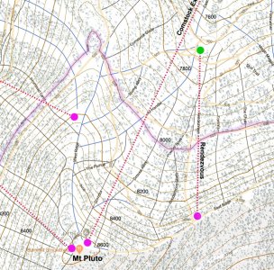
On the other hand, for the sake of better understanding where fresh untracked snow is unlikely to be tracked out at resorts with complex terrain, for decades, I've been creating maps from actual USGS topographic maps. In this era using caltopo overlays on USGS base maps, have created maps that also show where individual trees are. That is particularly valuable for understanding where trees in forest areas are less dense for fall line tree skiing as I frequently do. Also useful for understanding how to traverse into difficult to reach areas below steeps. Currently have highly detailed maps for Heavenly, Northstar, Kirkwood, and Winter Park that also contain lift information charts.
Below is a small crop from my Northstar map. The full map is 20x20.32 inches at 200 ppi that are intended to be taped together from smaller sections.

I agree, the perspective is it is for skier artwork. I think the best description is a blended collage or mashup of the trail maps. It is more for dedicated area skiers to recognize features of all the individual trail maps they stared at for hours as kids.Just I've never (consciously) seen a representation of a wider region and it brings it home how distorted it is to fit the brief being nothing like a pilot or any mapmaker would recognise i.e. it's more of an artwork than anything else.
@dbostedo I think Royal Gorge is probably immedicately abover your Sugar Bowl label and Boreal possibly below and left. Soda Springs to the right of Royal Gorege?
On that topic , if you were to compare to more "accurate" map artwork of the tahoe area, even 3d ones, the accurate pieces actually feel very bland and don't evoke any emotional connections. You have to have the Niehues painting.
So it pays to know your audience. I suppose for a pilot, they would prefer to have the artwork that used the exact map they used when flying ; a Calfire or Forest Service person would want USFS maps, a TrailHiker might want the Topo or USGS map.
@dbostedo : The small lump at approx 6 o'clock bottom I suppose is Tahoe Donner.
I'm trying to decipher everything on there... does this seem correct? Am I missing anything? Boreal or others?
View attachment 209745
EDIT: Redid the full map with labeling and updated my original post-
Last edited:
- Joined
- Aug 5, 2017
- Posts
- 1,625
Yeah, I was going to say that Sugar Bowl is "behind" Lake Mary, which seems exceptionally large in the regional illustration when compared to Donner Lake. Unless that's the meadow?? I once flew over NLT and down 80 on a commercial flight to SMF on a clear day, and it was a treat to spot all the resorts.
Good on you for getting Royal Gorge in the mix. Cool place.
I didn’t buy this for its usefulness as a map. I mean Heavenly is bigger than Tahoe in the painting. I bought it cause it’s cool art. I’d buy it again too, though maybe larger. Have a 2008 (?) Squaw Valley next to it. It’s a little less distorted.
I didn’t buy this for its usefulness as a map. I mean Heavenly is bigger than Tahoe in the painting. I bought it cause it’s cool art. I’d buy it again too, though maybe larger. Have a 2008 (?) Squaw Valley next to it. It’s a little less distorted.
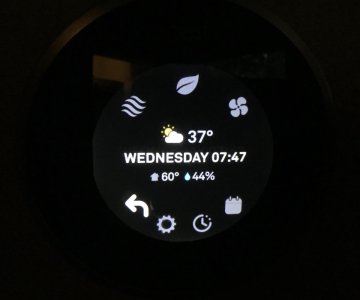
Umm.... I don't want to embarrass you or your phone/reading skills... but, uh... that clearly says 37 degrees.36° at my house in South Lake Tahoe this morning…
View attachment 210152

Sponsor
Staff online
-
Jim KenneyTravel Correspondent
Members online
- Wade
- LBK454
- BullMcCabe
- ScottB
- Jman
- neonorchid
- Even_Stevens
- ctsnowplow
- 4aprice
- RoccoH
- Bruce Neilson
- slidingmike
- esteban525
- David
- DerKommissar
- Wasatchman
- John Fritz
- Jim Kenney
- dusty
- Fuller
- Rich McP
- Plai
- GregK
- bbinder
- Ivan
- Pumpkin
- RTsucks
- Brian Finch
- Cheizz
- Atomicman
- coldski
- Gina D
- ajcolorado
- butleri
- SpeedyKevin
- oldschoolskier
- precisionchiro
- gwat
- Noodler
- maximlloa
- Bozzenhagen
- AngryAnalyst
- Mob
- TrueNorth
- Jmwils1
- smv
- Xiekai
- Uncle-A
- scrubadub
- AUdicky
Total: 2,549 (members: 105, guests: 1,834,robots: 610)


